The peculiar geographical location of the small town, surrounded by steep mountains, high peaks, sharp ridges, valleys and gorges, offers the visitor multiple options for walkers on the Sierra Xort, Alfaro and Serrella routes. High landscape interest itineraries ar suggested on the Sierra of Xortá, Serrella and Alfaro. With respect to the Sierra Xortá [Castell de Castells shared by the municipalities of Callosa d’En Sarria, Beniardá, Benimantell and Bolulla, there are some itineraries that start from Casteil of Castelis [552 meters] and lead, for example, the “Coll del Castell [850 meters), to the “Penya Alta” [1 21 8 meters), to the “Font dels Teixos” to the “Font de I’Ombria” to “Aro deis Atanços” and “Pla de l’Aialt”. Regardind Serrella [Shared sierra with Castell de Castells with the municipalities of Fageca, Famorca and Benasau, Beniardá and Confrides, we will find peaks as prestigious that bears the name of Serrella town (1 359 meters altitude], the “Pla de la Casa” (l 379 meters] and the “Maliada del Llop” [1361 meters]. In the Sierra de Alfaro [reaching 1 .165 meters high) is the Barrnc Malafí “and” Pla de Petracos” where you can admire the famous cave paintings, peculiar for its macroschematic art of Prehistory and the” Coya of Sorno “the” Clot de la Llacuna “,” The Cocoil”,”Font of Galistero”, etc.
FEATURES
Route of 16,480 km. By which you can enjoy two natural stone arches and several wells and buildings.
ITINERARY
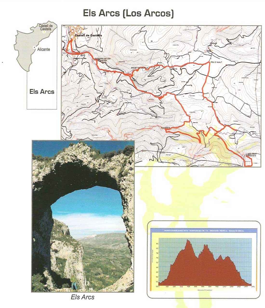 Starting from the Parking take the old road through Bolulla passing by la Fuente de Contreras, on the left on the CV-752 road towards Tárbena. At about 520 meters we turn right the PR-CV 145, we reach another crossroad with this continuing on the old Bolulla road. Crossing with the Real Azagador and passing by the Peña Escode, we find the Mirador of the Paratge Natural Municipal deis Arcs, where you can admire a spectacular view of the landscape. Then we walk by that Azagador to the junction towards el Bancal de Ambrós, where we will cross again with the PR-CV that leads to Arcs deis Atanços(recommended visit).
From here we will go on a path to the forest track that leads to Fuente de los Tejos y Morro Blau, we will follow the track to the left until you reach the crossroads of Xorquet. We continue on the right until you reach a path that will lead us to Liorna de Sacañar through Pou de Soriano, climb the Arc de Xorquet.
Returning to the last crossing, we will address it to visit, coinciding with the PR-CV 151, the Aljub Xorquet, returning north again and reach the next junction towards Tárbena, turning left about 50 m. and then right to arrive at Ayalt Pou.
Take the old road to Tárbena CV PR-145 passing through Pou de la Pujé, returning to the town.
FEATURES
It is a route of 12,920 kilometers. Which runs along the site of the Espel-la and the middle of the Sierra de Alfaro, through various fonts and wells and two old flour mills.
ITINERARY
 Leaving the road to Benichembla, leaving the village, to the take the old road of Famorca, can view the group of water elements composed of Fuente del Xorro, el Lavadero, irrigation pond and bridge-aqueduct towards the Rambla de Bit-la[river from Famorca].
Reaching that intersection on the right take the ancient road of VAll de Laguart to reach the place where it crosses with Benichembla road turning left and down to the riverbed, passing an old mill (molino Nuevo o Molí de Gomis) where the trail PR-CV 168 is caught up to the Fuente de Espel-la.
Here we leave the PR-CV 168 and follow the old Azagador that is opposite to that spring, up until the paved road leading to the Espel-las de Dalt, turning left and after about 200 meters we take the right on a forest path that leads to Pou de Caracolero and left follow the track to the next crossing, where we take the track on the left that leads us down the slope of the Sierra de Alfaro until Bancalot through next to the well with drinking trough which is on the right of two houses.
Then we have a asphalt road that reaches to Corrales de Bit-la, after crossing the old road we will arrive to Famorca and back to town.
FEATURES
Route of 10,912 Km. Which crosses the upper middle part of the Sierra de Serrella up the northeastern slope.
ITINERARY
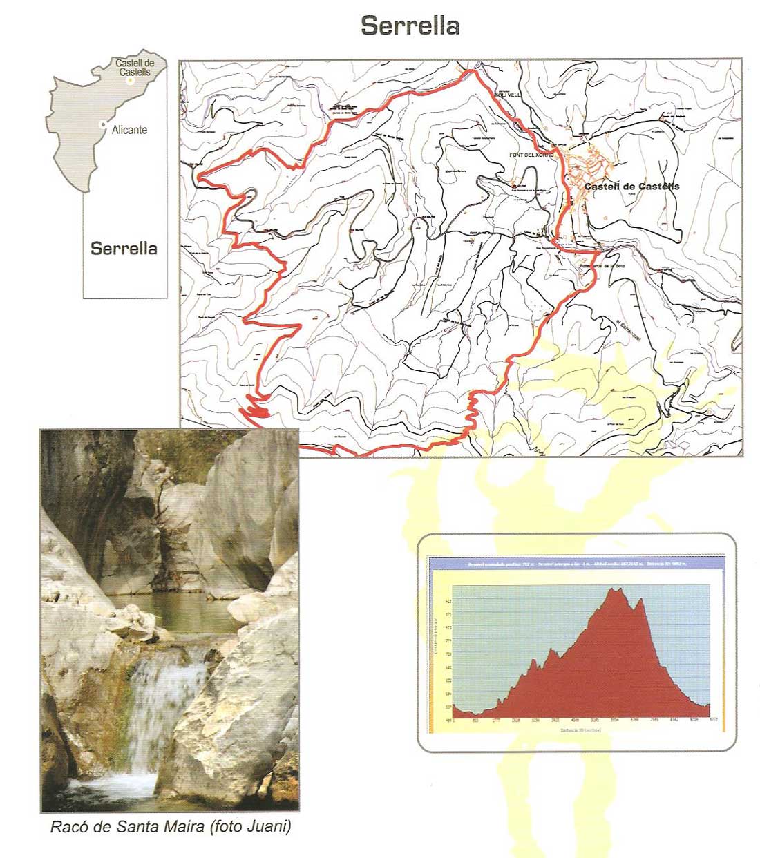 Starting from the parking lot along the road from Benichembla, just out of the town to the left by the old road of Famorca, passing the Font del Xorro, El Lavadero, the Irrigation Reservoir and Aqueduct coinciding with the PR-CV 168 we reach the Rambla de Bit-la. Following this path we pass the spectacular former Plaster mine [Algepsar del negra], continue this path to the junction of Famorca and following the signs we arrive at the Font Nova and Font de la Retura, We turn to the left and at the next junction we leave the trail and we will join a forest track that leads to Als Racons, After walking across the top of the mountains, descend down a path to the junction with the PR-CV 149 [the Castellet] through the Camping del Castellet to the junction with the Tárbena road, by Fuente de la Bota and back to the parking.
FEATURES
Route os 14,260 km. Which runs through places where you can enjoy various views of the village, as well as several old buildings
ITINERARY
 Leaving the parking lot and through the town along Calle San Roque and San Vicente we arrive to the beginning of Calle San Joaquin, we take the old road de Llacuna until we crossed the asphalt road from Els Golechavels near the Corral del fachero and about 100 meters to the left continue along the path of Llacuna.
During this journey we will passby an old and small open marble farm upto a forest track to admire the Clot de la Llacuna
On the right we continue along the forest trail to a detour, following the right we arrive at the Barrancada viewpoint where you can enjoy an excellent view of the whole valley, with the mountains of Serrella and El Faro..
Returning to the forest path we reach the junction with the old road of Tárbena PR-CV 46 until the Pou Ayalt. From here we will take the Azagador Real across the road to the old tack of Bolulla and reach the viewpoint of the Peña Escoda from where you can enjoy beautiful views of the Municipal Natural Park dels Arcs.
From this viewpoint we descend down a forest track that runs south to get a forest track that runs from Castell de Castells to Beniardá, right back to Castells direction to the crossing with the road, to the left Tárbena passing by the Fuente de la Bota and back to the parking.

